
Mt. Takagari – Reishoji Temple Hiking Course

25 min
20 min
30 min
1 hr 30 min
1 hr 10 min
20 min
30 min
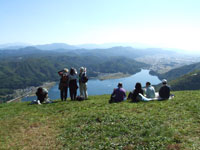
From the high ground overlooking Omachi City, enjoy views of the Northern Japan Alps at the Omachi Mountain Museum. From there, the course heads to its goal, Mt. Takagari.
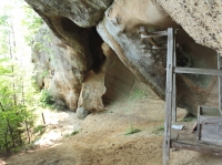
There is a sign for the trailhead entrance to the right of the museum. Walk through the woodland, crossing several paved roads. When you see the campground, take the stairs to a small shrine. From here, follow the paved road to the summit, where you can enjoy fantastic views from the bench and gazebo.
Mt. Takagari is a treasure trove of important plants. Volunteers have contributed to the development of the Mt. Takagari Viewpoint Park, where such plants can also be observed.
Reishoji Temple is a great place to view fall foliage, with giant ginkgo trees, and its main gate has impressive sculptures and a thatched roof. Go down the road in front of the gate and turn left at the end to join the road back to the Mountain Museum.
■ (Suitable for sneakers) Paved roads and slightly inclined walking trails
■ Walking distance: About 9 km from the Mountain Museum

Mt. Koguma Hiking Course
20 min
20 min
1 hr 45 min
1 hr 15 min
30 min
30 min
15 min
15 min
45 min
1 hr
30 min
45 min
30 min
45 min
This course connects Lake Kizaki and Kurosawa Highlands. It is a return course of trails and paved roads that can be enjoyed in either direction. We recommend driving to Kurosawa Highlands and making the round trip to the Lake Kizaki overlook. Enjoy the views as you walk to the viewpoint overlooking Lake Kizaki and the mountains behind. The mountain is named Koguma (bear cub) and, though rare, it is possible that you will encounter a bear. Please carry something, such as a bell, that will make a sound.
■ (Wear trekking shoes if possible) Paved roads and slightly inclined walking trails
■ Walking distance: About 14.5 km between Shinano Kizaki and Yanaba Stations
Round trip from Kurosawa highlands to Lake Kizaki outlook is about 9 km
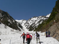
Harinoki Nature Trail Hiking Course
Car 30 min
Car 30 min
1 hr 20 min
1 hr
30 min
20 min
A course from Ogisawa to Harinoki Snow Gorge, one of Japan’s three major snow gorges. The starting point is Ogisawa, the eastern gateway to the Tateyama Kurobe Alpine Route. While hiking, you can enjoy the forest and even try touching the meltwater stream if you like.
■ (Trekking shoes) Mountain trail with inclined slopes
■ Walking Distance: About 7 km from Ogisawa to Harinoki Snow Gorge (altitude approx. 1,850 m)
* Every year, on the first Sunday of June, the hiking event called “Harinoki Shintaro Festival” is held to honor Shintaro Momose, an Omachi born mountain guide who made great contributions to his profession.
Yumata Hiking Course
30 min
30 min
15 min
15 min
2 hr 30 min
2 hr 30 min
30 min
20 min
15 min
15 min
1,620 m
1,430 m
Starting from Takase Dam, Japan’s highest rock fill dam, the path follows the river upstream for 2 hours 30 minutes to Yumata Hot Springs. Here, you can see Funtokyu, hot springs mineral deposit mounds, one of Japan’s natural monuments. It lies about 15-minute walk from where the suspension bridge crosses the Minamata River. Most of large mounds are now inactive, but you can find other spots where spring water may create future formations. It is a gift from nature that everyone who sees is sure to cherish.
* Climbing for 30 minutes on the path behind Seiranso will bring you to a viewpoint where you can enjoy fantastic views of the valley. A 2-day, 1-night trip with a stay at Seiranso is most enjoyable.
See also Takase Gorge page.
■ (Suitable for sneakers) A mostly flat unpaved path
■ Walking distance: Round trip from Takase Dam to Funtokyu is about 21 km
Mt. Kuwanomine Hiking Course
15 min
15 min
3 min
3 min
2 hr
1 hr 30 min
An enjoyable course to Mt. Kuwanomine known for its beautiful rhododendron blooms. (The best time for viewing the flowers is from late May to early June.) This course includes a steep section with ropes. Also some parts of the course follow the cliff side so please proceed with caution in these sections.
■ (Wear trekking shoes if possible) A mountain path with steep slopes
■ Walking distance: Round trip from the Mt. Kuwanomine trailhead is about 5 km
Mt. Oba Hiking Course
45 min
45 min
45 min
35 min
20 min
15 min
15 min
20 min
45 min
1 hr
The legends of this land still remain at this mountain. A short straight climb of the ridge, this thrilling course has rocky sections with chains.
From the Nunokawa pass, the Oba footpath is a relatively flat path where you can enjoy ‘forest bathing’.
■ (Wear trekking shoes if possible) A mountain path with steep slopes
■ Walking Distance: From Oba Main Shrine trailhead to Nunokawa Pass trailhead is about 4 km
Basic Equipment for Hiking
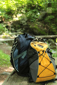
- Trekking or athletic shoes
- Long sleeved shirt (on hot days it is recommended to wear a T-shirt underneath)
- Pants (so that your skin is not exposed to get an injury, strong ones)
- Hat & Raingear (separate type)
- Rucksack, Water bottle, High energy food
- Map, Compass, Bell (something that will make a loud sound to avoid bears)
- Watch, Garbage bags, First-aid kit
* This is equipment required for hiking. For full-fledged mountain climbing, you need additional specialist equipment.
 Hot Springs